Southwestern United States

The Southwestern United States is a region defined in different ways by different sources. Broad definitions include nearly a quarter of the United States, including Arizona, California, Colorado, Nevada, New Mexico, Oklahoma, Texas and Utah. Narrowly defined, the "core" Southwest might include only Arizona and New Mexico, with parts of the other states making up the beginnings and endings of the Southwest.[1]
Most of it was a part of the Viceroyalty of New Spain, in the Spanish Empire, during the Modern Era.
Contents |
Regional geography
The geographer D. W. Meinig defines the core of the Southwest as the portion of New Mexico west of the Llano Estacado and the portion of Arizona east of the Mohave-Sonoran Desert and south of the "canyonlands", and also including the El Paso district of western Texas and the southernmost part of Colorado.[2] He identifies four distinct subregions with this core.
He calls the first subregion "Northern New Mexico", and describes it as focused on Albuquerque and Santa Fe. It extends from the San Luis Valley of southern Colorado to south of Socorro and including the Manzano Mountains, with an east-west breadth in the north stretching from the upper Canadian River to the upper San Juan River. Important ethnic groups include Hispanos, Anglo-Americans, and the Puebloan peoples. The area around Albuquerque is sometimes called Central New Mexico. During the Spanish era the term Rio Abajo and Rio Arriba were used for the settled areas around Albuquerque and Santa Fe, respectively.[3] During the 19th century Hispano people expanded north into the San Luis Valley west of the Sangre de Cristo Mountains, and east of the mountains along the Purgatoire River in Colorado. Hispano expansion to the east reached into the Texas Panhandle and, to the west, along the San Juan River and Little Colorado River into Arizona.[4]

"Central Arizona" is vast metropolitan area spread across one contiguous sprawling oasis, essentially equivalent to the Phoenix metropolitan area. The city of Phoenix is the largest urban center, and located in the approximate center of the area, but it is just one of many urban centers, such as Tempe, Mesa, and many others. None are clearly dominant although the whole can be considered the greater metropolitan area of Phoenix.[5]
Meinig calls the third subregion "El Paso, Tucson, and the Southern Borderlands". While El Paso and Tucson are distinctly different cities they share a similar and somewhat overlapping hinterland between them. El Paso is about half Hispano and, with Ciudad Juárez, just half of the largest metropolitan area along the Mexico – United States border. Tucson occupies a large oasis at the western end of the El Paso-Tucson corridor. The region between the two cities is a major transportation trunk with settlements servicing both highway and railway needs. There are also large mining operations, ranches, and agricultural oases. Both El Paso and Tucson have large military installations nearby; Fort Bliss and White Sands Missile Range north of El Paso, and, near Tucson, the Davis-Monthan Air Force Base. About 70 miles (110 km) to the southeast are the research facilities at Fort Huachuca. These military installations form a kind of hinterland around the El Paso-Tucson region, and are served by scientific and residential communities such as Sierra Vista, Las Cruces, and Alamogordo. El Paso's influence extends north into the Mesilla Valley, and southeast along the Rio Grande into the Trans-Pecos region of Texas. The entire region has a large Hispano population. The Native American Tohono O'odham and Yaqui Native Americans continue to preserve cultural traditions and link Tucson with native lands to the west and south.[6]
The fourth subregion Meinig calls the "Northern Corridor and Navaholands". A major highway and railway trunk connects Albuquerque and Flagstaff. Just north of the transportation trunk are large blocks of Native American land. Once regarded as a bleak wasteland populated by a dying culture, the native cultures, especially the Navajo Nation, have undergone a strong resurgence and is playing an increasingly important role. Other tribes such as the Hopi and Zuni have also experienced a similar resurgence. Several towns and cities serve as contact points between the native peoples and other groups. Notable examples include Farmington, New Mexico, Gallup, Window Rock, Arizona, Flagstaff, Arizona, and, to a lesser degree, Prescott, Arizona. In the Little Colorado River and Mogollon Rim country there is an old and continuing Mormon influence. Many old Mormon settlements have grown rapidly with the arrival of migrants mainly from Texas, the American South, and the Pacific Northwest. Districts around old Mormon villages such as Ramah, New Mexico are often populated by a mix of at least five ethnic groups and culture, such as Mormons, Pueblo Zunis, Navajos, Hispanos, and Texans.[7]
The Phoenix metropolitan area dominates the western half of the Southwest's core region, so much so that it subordinates the subregions around Flagstaff and Tucson. Thus the basic spatial structure of the Southwest can be seen as focused on the three largest metropolitan areas of Phoenix, Albuquerque, and El Paso. This core of the Southwest is directly linked to other regions. The Mojave Desert separates it from Southern California. Several corridors and urban centers in the desert link the two region, most significantly at Las Vegas, Nevada, where the Arizona and California systems interlock. The Mormon Corridor links the Southwest to the main body of Mormon settlements in Utah. Mormons have colonized areas of Arizona and New Mexico since the 19th century, especially in the San Juan Basin near Farmington and along the Mogollon Rim and Little Colorado River in Arizona. Las Vegas also served as a pivotal point of Mormon Corridor between Utah, northern Arizona, and southern California. These areas link the Southwest with the main concentration of Mormon settlements in Utah and eastern Idaho. New Mexico is directly linked with Colorado, with cities such as Durango, Alamosa, Walsenburg, and Trinidad having characteristics of both regions. The Southwest is loosely linked with the Midwest in northeast New Mexico, into which the grain farming system of Kansas had been extended. The Southwest-Midwest link via the Santa Fe Trail was historically of enormous importance. The Southwest is linked to Texas in eastern New Mexico, especially along the Pecos River and on the Llano Estacado, where an early mass influx of Texan farmers was later reinforced by the oil industry. Roswell, New Mexico occupies a border position between Albuquerque and the Texan system. Finally, the Southwest is intimately linked to Mexico, most tightly at El Paso and Ciudad Juarez and secondarily at Tucson and Nogales.[8]
History
With the European colonization of the Americans, New Spain, later to become Mexico was dominant until the 19th century. With Manifest Destiny, United States gradually gained control over the west. Pro-Confederate Texas and Pro-Union Utah were important at this point, although California rapidly became the main western power. Utahns moved west into Nevada and Northern California, whereas Texans moved into New Mexico and Arizona. Parts of New Mexico and Arizona were briefly a Confederate territory, then were transformed into a Union territory, then Union state. Arizona's original government and military were similar to those Texas at the time had. Arizona, in the form of the Gadsden Purchase also has connections to the Republic of Sonora. The southwest takes up about a third of the United States.
Vegetation and Terrain
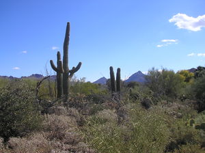
Vegetation of the Southwest generally includes various types of yucca, along with Saguaro Cactus, Barrel Cactus, Prickly Pear Cactus, Desert Spoon, and Creosote Bush to name a few. These examples (except the Saguaro Cactus), can be seen growing natively and in large numbers more east throughout the Texas Hill Country and South Texas and the Rio Grande Valley. Therefore some may consider the Southwest to begin in these areas since they not only share culture with the rest of the Southwest, but a lot of the native vegetation as well. However, none of the vegetation discussed grows natively the further east one gets past San Antonio, Austin, and even the western outskirts of Fort Worth. Dallas and Houston, for example, with regards to vegetation and terrain more the American South. Landscape features of the core Southwestern areas of New Mexico and Arizona usually include mountains, and semi-arid to arid terrain. The eastern part of the Southwest, for example the Texas Hill Country, consists of dry, tall and rugged rocky hills of limestone and granite. South Texas and the Rio Grande Valley is mostly flat with many places consisting of scrub and bare topsoil, much like the deserts further west.
Ethnicity
The Southwest is ethnically varied, with significant European American (especially in the Texas Hill Country) and Hispanic American (in New Mexico, Arizona, California, and South Texas/Rio Grande Valley) populations in addition to more regional African American, Asian American, and American Indian populations.
Cities and urban areas
The area also contains many of the nation's largest cities and metropolitan areas, despite relatively low population density in rural areas. Phoenix and San Antonio are among the top ten most populous cities in the country[9] and two of the fastest-growing cities in America. Many of the states in this region, such as Arizona, Nevada, New Mexico and Texas have witnessed some of the highest population growth in the United States; and according to the U.S. Census bureau, in 2008–2009, Utah was the fastest growing state in America.
References
- ↑ Meinig, Donald W. (1971), Southwest: Three Peoples in Geographical Change, 1600–1970, New York: Oxford University Press, pp. 3–8, ISBN 0195012887
- ↑ Southwest, pp. 3–8
- ↑ Southwest, pp. 95–101
- ↑ Southwest, pp. 28–29
- ↑ Southwest, pp. 103–106
- ↑ Southwest, pp. 112–114
- ↑ Southwest, pp. 114–119
- ↑ Southwest, pp. 123–136
- ↑ 50 most populous cities in the U.S., Infoplease.com
External links
|
||||||||||||||||||||||||||||||||||
|
||||||||||||||||||||||||||||||||||||||||||||||